Quiet center vs noisy outskirts: where is it actually more comfortable to live?
Why we choose one thing and burn out on the other — and whether you can find your own "third way." This article isn't about pros and cons, but about how to measure your personal index of everyday happiness and stop guessing.

City center
Everything within walking distance, bike share at your doorstep, theaters and restaurants three minutes away. But according to the "Urban Life Balance 2025" survey, 68% of downtown residents dream of quiet, and every other person regularly wakes up to street noise.
Outskirts
Clean air, spacious courtyards, and real silence. But a Friday trip to the store turns into a logistics operation, and a spontaneous meet-up with friends is nearly impossible.
The paradox is simple: both the center and the outskirts promise comfort, but each takes its own price. The question isn't which side to pick, but whether you can learn to measure what matters more to you — minutes to the store or silence outside your window.
Why this question became the main one right now
Remote and hybrid work flipped the idea of a "good location." We used to anchor ourselves to the office; now we anchor to the quality of the environment. You're no longer obliged to live 20 minutes from the business district, but you still have to buy bread every day, take kids to daycare, and breathe air without toxic pollutants.
The problem is that familiar criteria like "prestigious neighborhood" or "near the subway" no longer reflect real comfort. You can live on a quiet side street and spend 12 hours a week getting to an ordinary clinic. Or you can live on a noisy avenue but have a park in the courtyard where you hear birds, not the highway.
If you keep choosing housing by the picture and two or three pins on the map, you risk quietly trading convenience for the illusion of convenience. And only when you start measuring minutes instead of kilometers does the picture flip.
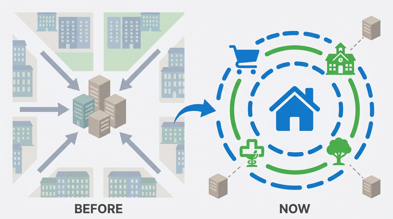
Work no longer dictates location — everyday routes determine how tired you are by evening.

"We spend time getting to places where we want to spend time. And if the commute takes more than an hour a day, no balcony with a park view makes up for it."
Urban comfort is less about square footage or number of floors than about the weekly time budget spent on everyday trips. The smaller it is, the better your chances of actually living — not just moving between home and necessary stops.
Three misconceptions that keep you from seeing a place's real quality
Myth 1. "Closer to the center = more convenient in everything"
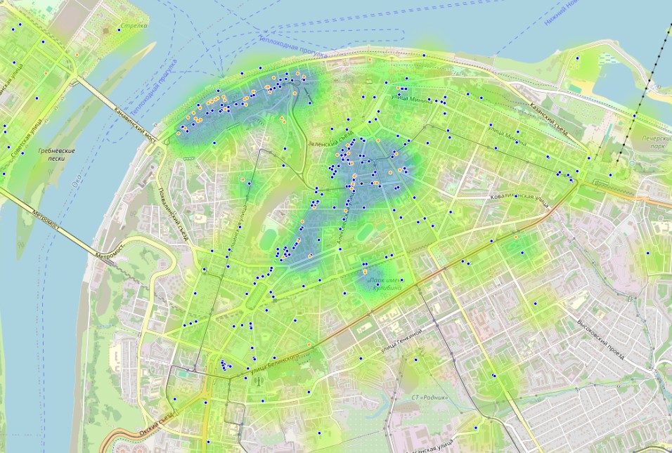
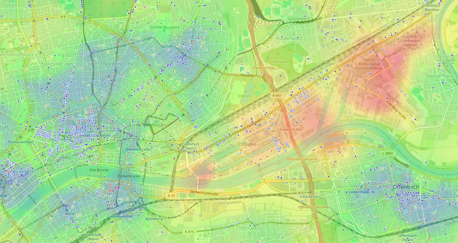
We're used to equating the center with a concentration of amenities. But that same concentration brings noise, nightclubs, polluted intersections, and perpetual traffic. Proximity to "red" objects — factories, busy roads, construction sites — shifts the environmental balance against the resident.
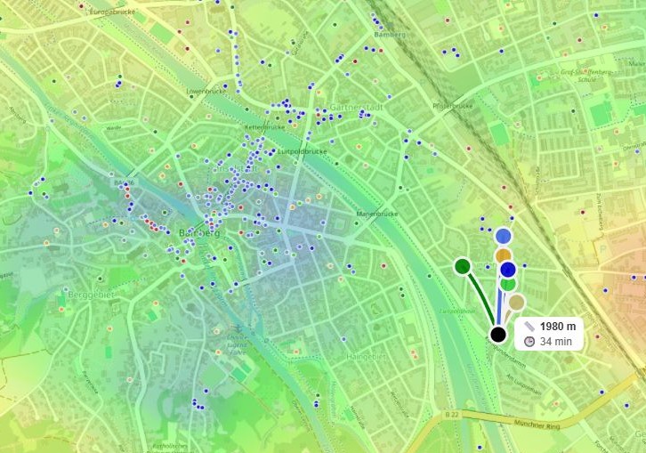
On urban environment heat maps it's clearly visible: the center is often colored in alarming shades, while "green" oases hide in non-obvious places — on the border of residential areas and park zones. Convenience is defined not by distance to the main square, but by walkability to everyday places and the absence of aggressive irritants.
Myth 2. "The outskirts are always quiet and cheap, but completely dead"
Many think distance automatically brings peace but strips you of civilization's benefits. In reality, modern outskirts are highly uneven: there are neighborhoods with perfect "15-minute city" infrastructure, and there are "sleeping ghettos" where the nearest supermarket is a 25-minute walk along the roadside.
The misconception persists because we rarely compare weekly time costs — we just look at the map. But 10 minutes to the pharmacy versus 5 minutes in practice adds up to several extra hours per month if you go regularly. Outskirts "deadness" isn't a sentence — it's a planning question.
Myth 3. "Just look at the map and drive through once"
Visual assessment
A pretty courtyard doesn't show night factories or missing sidewalks to the school.
Single trip
15 minutes to the subway on Sunday morning — 40 minutes on a weekday evening every day.
Relying on hearsay
Someone else's "good neighborhood" almost never matches your life pattern.
What you actually need to measure: three pillars of "quiet comfort"
1. Walkability, not radius on the map
The idea of "nearby" is deceptive. A store 400 meters as the crow flies can be 700 meters on the real route with no sidewalk. Jeff Speck's research has repeatedly shown: people willingly walk up to 800 meters if the path is convenient, interesting, and safe. Beyond that, the brain switches to "fatigue mode."
Focus on walking time for key categories: grocery store — up to 10 minutes, daycare or school — up to 12 minutes with a child, pharmacy and clinic — up to 12 minutes, park or square — up to 8 minutes. Everything beyond these windows starts eating your resources invisibly, day after day.
2. Environmental balance: not just pluses, but neutralizing minuses
Environmental balance scale
Object influence coefficient on comfort
A park on its own doesn't make a location comfortable if the next courtyard has a concrete plant. We're used to counting pluses while forgetting minuses that work against us around the clock.
Every object around your home has an influence coefficient: from −10 (factory, nightclub, highway) to +10 (park, museum, quiet terrace). The final index is the sum of overlapping radii. Several weak pluses may not offset one strong minus if you live at its epicenter.
Assess the surroundings in three layers:
- Red layer: noise, smells, visual clutter — factories, garages, bars open until morning.
- Yellow layer: schools, stores — activity, but not around the clock.
- Green layer: parks, waterfronts, libraries — recovery zones.
A comfortable location isn't one with lots of green, but one where the red layer is absent or its radius doesn't overlap your window of silence.
3. Weekly time budget instead of distances
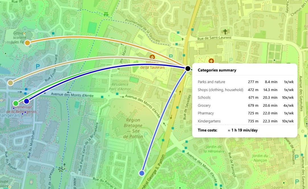
Between "far" and "close" stands the number of hours of your life you exchange for the commute.
Stop thinking in kilometers. Calculate weekly costs for recurring routes:
- Daycare: 2 times a day × 15 min × 5 days = 2.5 hours
- Work (hybrid): 3 days × 40 min one way × 2 = 4 hours
- Groceries: 3 times × 20 min = 1 hour
- Sports / park walk: 4 times × 10 min = 40 min
- Other (pharmacy, dry cleaner, café): about 1.5 hours
Total: ~10 hours per week on everyday trips alone. That's a full workday you're not living.
Across locations, the spread can range from 5 to 18 hours per week. A difference of 10 hours every week is 520 hours a year — almost 22 full days. That's the number worth comparing to rent or mortgage price.
How to measure everyday comfort on your own: a step-by-step checklist
Make a list of "anchor points"
Write down 7–10 places you visit at least twice a week: work, daycare, school, store, park, pharmacy.
Map walking routes
Plot the path from your front door to the building entrance — not as the crow flies. Record minutes for each route.
Estimate frequency and calculate the week
Multiply time by weekly visits. Up to 7 hours — excellent, 7–12 — acceptable, over 12 — high burnout risk.
Apply the "red filter"
Walk the area in the morning, Friday evening, and at night. A steady source of disturbance within 200–300 meters is a serious minus.
Compare locations on a single scale
Table: addresses in rows, weekly time budget, red objects, green layer in columns. Only then does the magic of the "cute courtyard" disappear.
Common mistakes at each stage
- Not checking the route during rush hour
- Focusing only on the subway, forgetting the "last mile"
- Ignoring noise from schools and playgrounds
- Not accounting for 24-hour pharmacies and emergency services
The complexity we solved for you
The most labor-intensive step in the checklist is objectively calculating environmental balance and overlaying influence zones of dozens of objects. Gathering and weighing this manually can take weeks, and there's still room for error.
That's exactly why we built HotMap — a geospatial tool that shows the "temperature" of the urban environment at a glance. You turn on the "Quiet and calm" scenario, and the map lights up so green comfort oases become visible without a single calculation.
All that's left is to look: here is the real quiet center you dreamed of, even though on an ordinary map it looks like a regular residential block.
See how it works on your own example.
Not a recap, but a synthesis
We're used to dividing the city into center and outskirts, noisy and quiet, expensive and affordable. But real comfort doesn't follow this binary code. It's fine-tuning: your minutes to the bakery, your level of nighttime quiet, your balance between the energy of the avenue and the peace of the courtyard.
The paradox resolves simply: both in the center and on the outskirts there are islands of convenience and zones of invisible stress. The question isn't "where," but "how to measure." When you translate quality of life into concrete numbers — commute minutes, influence radii, weekly time budget — the choice stops being a lottery.
Finding a place where it's truly easy to live isn't intuition or luck. It's the skill of looking at the environment with the right tools. Start by counting minutes and "red spots" around you — and you'll be surprised how many worthy options you never noticed before.
Frequently asked questions
Does the time-budget method work in small cities too, or is it only for megacities?
It absolutely works. In a compact city, the difference between "everything within walking distance" and "need to call a taxi for any errand" is even more noticeable, because car infrastructure is often underdeveloped. A 20-minute walk to the clinic in a city of 50,000 isn't the norm — it's a reason to reconsider.
What if I already bought an apartment and only then calculated — the numbers are bad?
Comfort can be fine-tuned: change habitual routes, add a bike or scooter link for the "last mile," adjust departure times. But the main thing — you'll plan your next move with numbers, not emotions.
Can an app really replace the live feel of a neighborhood?
The app doesn't replace feeling — it removes "blind spots" impossible to sense on a single walk: nighttime noise, concentration of "red" objects, real walkability in minutes. The live impression remains an important final check, but only after the numbers confirm: this place is worth paying attention to.